Sunday, October 23, 2016: And, hopefully, the completion of our Anacortes to San Francisco Cruise
This morning we departed Bodega Bay in the near early morning darkness. We're bound for the Golden Gate at around 2PM near slack current. Then it's down the Bay to Redwood City and Westpoint Harbor arriving around 4PM where we expect to keep the Wild Blue for several months. Once again we're in front of a new set of storms that are expected to thrash the ocean starting tonight. Hopefully we'll finally complete this journey southward after planning an early to mid-October finish.
This morning's leg is usually ugly as the swell and seas come from the northwest and our course is initially southwest to clear Point Reyes. This puts the seas on our beam, beyond what the roll stabilizers can handle. So any loose furniture, unsecured table items, and unlatched drawers can become mobile as they did on this leg in September 2013. We expect to get a little current push at point Reyes. Check back later.
10:30AM Update:
The fog arrived about an hour into our motor to Point Reyes. It then cleared just after the Point. Surprisingly the ocean is mild today, way less than the forecast 6 foot swell, and all furniture is staying put this time! Winds are below 5 knots so far. Expecting the Gate around 1:45PM. Later.
Fog bank reduces our visibility to about 200 yards.
Point Reyes Light. Known for its great Blue Cheese!
2:30PM Update:
We safely navigated over the San Francisco Bay Bar, under the Golden Gate and across the busy Bay. Just 90 minutes and we'll be ready to tie the boat at Westpoint Harbor for a few months and enjoy the NoCal winter. It been a fun but lengthy cruise southward, and sometimes seeming a bit like a chore rather than a boat cruise. Thanks to Dick Squire and Denny Haythorn for their, as always, excellent crew work aboard the Wild Blue in sometimes exciting conditions.
Have a great winter...... Alex
Point Bonita just northwest of SF Bay entrance
The gate with tower tops missing.
The City
Dick is cleaning up bow area, and taking a bow for good crew work.
Now in his mid-eighties, Dick has owned some 30+ sail and
power boats. His most recent Seagate, a GB East Bay 44 that does
30+ knots, was delivered this past June. He's every boaters idol!
The NOAA Marine Forecast early this morning called for Small Craft Warnings. Most of the wind and wind waves will occur from noon to midnight tonight south of Point Arena. So we have delayed our 4:30AM departure from Eureka and now plan to cruise direct to Bodega Bay, a 21-hour motor, avoiding the worst forecast below Point Arena. By leaving mid-morning today, we can expect Bodega by tomorrow's early morning daylight.
The forecast is:
CAPE MENDOCINO TO PT ARENA OUT 10 NM-830 AM PDT FRI OCT 21 2016
SMALL CRAFT ADVISORY IN EFFECT FROM THIS EVENING THROUGH
SATURDAY EVENING
TODAY...NW WINDS 5 TO 15 KT. WAVES NW 3 FT AT 5 SECONDS...AND
NW 7 FT AT 11 SECONDS.
TONIGHT...N WINDS 5 TO 15 KT. WAVES NW 10 FT AT 14 SECONDS.
POINT ARENA TO POINT REYES TO 10 NM-902 AM PDT FRI OCT 21 2016
SAT...NW WINDS 10 TO 20 KT. WIND WAVES 2 TO 4 FT. W SWELL 8 TO
10 FT AT 15 SECONDS.
In both Dick's and Alex's opinion, this forecast doesn't call for a Small Craft Warning especially for boats southeast bound. Just maybe a Tiny Craft Warning is in order as the winds, swells and waves should be behind us.
Will update if cell communications available, but we don't expect any .......
Saturday, October 22, 2016 6:00AM: Arrived in Bodega Bay
The 15-20 knot NW winds, NW wind waves and NW swell all combined to shorten our cruise by an hour. So instead of arriving in early morning light, it was in the dark. Instead of a 21-hour run, it was just 20.
It started out with a few giant swells while exiting Eureka, aka Humbolt Bay. At first we thought the forecast 7-foot swell at 11 seconds was wrong, but once away from the Bay entrance, the swell reduced to 4-foot. The ebb current across the shallow bar temporarily increased the swell to about 12-foot.
From Eureka to Cape Mendocino, about 20 miles, the winds were NNW and less than 6 knots. 6-foot seas on the beam made for a bumpy ride. From Cape Mendo to Punta Gorda for about 15 miles, we had 15 knots NNW with 8-foot seas. At Punta Gorda we hit steep NW seas and an adverse 2-knot current. But once clear of the Point, the current slacked and we started doing 9's and 10 knot boat speed. From Gorda to Point Arena about 88 miles, we had from 12 to 20 knots of NW winds with NW 8 foot seas and BIG wind chop. With the RPM boosted to 1400, the boat Speed-Over-Ground showed solid 9's with peaks of 11+ knots! The boat did fine in the following seas but occasionally the roll stabilizers and the autopilot worked against each other, causing deep a roll, or two.
Dick and Alex ran on 2-hour watches, changing on the even hours. In became so routine that once in port neither of us could sleep without waking up after 2 hours.
Our plan is to leave at 7AM tomorrow for San Francisco and we hope to beat the next series of storms coming tomorrow night.
USCG Barracuda watches as we Depart Humbolt Bay
Cape Mendocino, some call Cape Horn of the Pacific.
Crew Dick Squire drove from his Malibu home to San Luis Obispo this morning. Alex joined him for the road trip back to Crescent City. Last week when the big storms blew into the Pacific Northwest, it was clear the ocean would be nasty for at least 5 days. So Alex rented a car and the crew drove home to southern California. Tuesday and Wednesday we made our way back to the boat.
It's a 13 hour drive from LA to Crescent City. We stopped in Healdsburg to recoup and then on to the boat on Wednesday. The Wild Blue weathered the storms quite well. There was dockline chaff and all the lines seemed about 10% longer! We re-provisioned, paid the dock fees, returned the car to Hertz and dined aboard. There were some rental car struggles, such as lost keys, a cracked windshield, unfilled fuel tank, towing requirement, etc, but these were easily overcome by paying more money.
On the docks we met the crew from a large ketch that had laid out gear to dry all across the floats. Sails, clothes, mattresses, lines, bedding, etc were all soaking wet. The boat looked somewhat weathered so we asked the crew about the storm. Unfortunately they were just one day behind us but got caught at sea in those 40-knot winds and 20-foot seas. Their boat was knocked down on beam ends twice, dislodging the engine from its mounts. With a dead engine they were towed into Crescent City by the Coast Guard.
Thursday, October 20, 2016: Crescent City to Eureka
This morning we exited City harbor at 6:30. Outside we enjoyed bumpy seas in calm winds. The 5-foot swell was westerly, directly on the beam, so the roll stabilizers got a good workout. Didn't see one boat for the first 6 hours then a commercial fisher was just ahead of us as we entered Eureka. The Eureka bar was just fine and we tied up at Woodley Island Marina about 2:45PM.
The plan is to depart Eureka at 4:30AM tomorrow for Little River anchorage just below the City of Mendocino, a 13-hour motor. We arrive about an hour before sunset, and if the anchorage is calm, we will spend the night. Otherwise we'll tough it out as long as we can stand it, then head for Bodega Bay, another 9 hours. Plan to dine with Alex's college friend Willie Benedetti, the turkey farmer, in Bodega on Saturday. The Wild Blue probably won't show up on MarineTraffic.com as there is not much cell communications around Cape Mendocino. If the Little River Inn's wifi is still open, or if cell service is available, we'll update the blog.
Here's the projected schedule:
Oct 21-Friday: Little River Anchorage 13 hours
Oct 22-Saturday: Bodega Bay 9 hours, Spud Point Marina
Oct 23-Sunday: San Francisco 9 hours
US Coast Guard off Eureka entrance
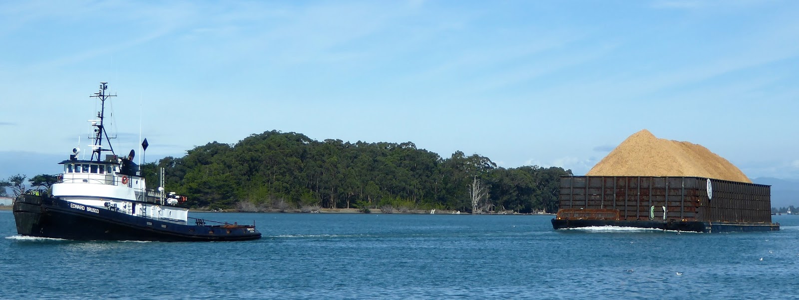
Edward Brusco and wood chip barge exiting Eureka bound for Wuona, OR.
The Wild Blue is here in Crescent City tied to the dock. We have doubled the stern, bow, and spring lines and added redundant mid-line all secured to the City dock. A Lagoon 43 cat and Nordhavn 64 are also tied up here along with numerous commercial fishing boats. All have exited the ocean and are secured in the Harbor due to the following weather:
PT ST GEORGE TO CAPE MENDOCINO OUT 10 NM AT 235 PM PDT FRI OCT 14 2016
SMALL CRAFT ADVISORY IN EFFECT THROUGH LATE TONIGHT
GALE WARNING IN EFFECT FROM LATE TONIGHT THROUGH SATURDAY AFTERNOON
TONIGHT
S WINDS RISING TO 20 TO 30 KT WITH GUSTS TO AROUND 40 KT LATE. WAVES S 4 FT AT 8 SECONDS AND W 16 FT AT 15 SECONDS SLIGHT CHANCE OF TSTMS.
SATURDAY
S WINDS 30 TO 40 KT WITH GUSTS TO AROUND 50 KT.
WAVES S 13 FT AT 9 SECONDS...AND W 12 FT AT 14 SECONDS.
SLIGHT CHANCE OF TSTMS.
SATURDAY NIGHT
S WINDS 10 TO 20 KT WITH GUSTS TO AROUND 35 KT.
WAVES S 5 FT AT 9 SECONDS...AND W 14 FT AT 14 SECONDS.
SLIGHT CHANCE OF TSTMS.
SUNDAY
S WINDS 20 KT. WAVES W 13 FT AT 12 SECONDS.
SLIGHT CHANCE OF TSTMS.
SUNDAY NIGHT
SW WINDS 10 TO 15 KT. WAVES W 14 FT AT 12 SECONDS.
SLIGHT CHANCE OF TSTMS.
MONDAY
S WINDS 10 TO 15 KT. WAVES W 13 FT AT 13 SECONDS.
TUESDAY
NE WINDS 5 TO 10 KT. WAVES W 10 FT AT 13 SECONDS.
WEDNESDAY
N WINDS 5 TO 10 KT. WAVES W 8 FT AT 14 SECONDS.
So it looks like we will get back on the water Thursday or Friday this coming week. Have a nice week.
It's a fine morning out here in the Pacific just a few miles west of Bandon, Oregon. We woke up our boat neighbors as we motored out of Coos Bay this morning at 3:50AM. Outside the ocean was, and continues to be, f-l-a-t. Just perfect for motoring boating with less than 5 knots of breeze and visibility over 20 miles, as we could see the Cape Blanco light at 21 miles.
We expect this day to be our last ocean cruise for a week while a BIG Pacific storm sweeps into the northwest, the remnants of an Asian typhoon. Winds over 40 knots and waves approaching 20-feet will keep us in port until Wednesday or Thursday next week. We expect that port to be Crescent City at around 5PM today.
10:40AM Update:
This humpback fin fight was just occurring off the
Rogue River Reef
Crossed the Yaquina River Bar and on our way to Coos Bay. It's a 10-hour run today so we expect to be in Coos Bay by 5PM or so. Today's weather report is in two parts:
From Newport to Florence, Oregon:
TUE...NE WIND 5 TO 10 KT WITH GUSTS TO 15 KT... BECOMING N IN
THE AFTERNOON. WIND WAVES N 1 FT AT 4 SECONDS. NW SWELL 5 FT AT
14 SECONDS.
From Florence to Coos Bay:
TUE...N WIND 10 KT...BACKING TO NW IN THE AFTERNOON. WIND WAVES
2 FT OR LESS. W SWELL 3 TO 4 FT AT 13 SECONDS.
Looking forward to as nice a day as yesterday.
3:30PM Update:
It's been a very nice day on the ocean. 3 to 4-foot seas generously spaced apart, winds less than 9 knots and mostly 5 knots or less, all in bright sunshine. The Coos Bay bar is open and we expect to cross by 4:15PM.
Tomorrow we have an early departure at 4:00AM for the 13.5 hour run to Crescent City.
This morning we left Tillamook with about three dozen of other small sports-fishers. The Tillamook River bar was tame, Tillamook Coast Guard deemed it unrestricted, and since this is Columbus Day, the boat people were out in force.
Some of these small boats seemed quite scary to be out on the big ocean. Not sure what would happen to these boaters if the bar was restricted. So it's a gamble for them to know how long to fish, yet be able to reenter port when the weather turns, but before the bar is restricted. You can see the exodus of small boats in this 10 X speed video.
10:30AM Update:
The ocean is nice today. The wind will increase this afternoon. We plan to be in Newport just after 2PM. Today's forecast is:
TODAY...N WIND 10 TO 15 KT WITH GUSTS TO 20 KT. WIND WAVES N
3 FT AT 4 SECONDS. W SWELL 6 FT AT 14 SECONDS. SECONDARY SWELL W 3 FT AT 9 SECONDS.
The BIG story out here happens starting Wednesday evening. A gale with winds to 35 and seas to 17 feet is expected for Wednesday night, Thursday and Friday. We plan to be in Crescent City Harbor by Wednesday early evening. If the weather forecast doesn't improve within about three days of arriving, we'll consider renting a car and heading home for a week or so.
1:30PM Update
We're off Cape Fowlweather and the Cape is not living up to its name today, thank goodness.
Rocky Creek Bridge at Cape Fowlweather, Oregon
Yaquina Head Light
2:30PM Update:
We arrived in the Port of Newport at South Beach Marina. It was a nice sunny day, the wind blew a bit more, but the Yaquina River bar was easily passable. Tomorrow we leave at 7AM for Coos Bay. Roger. Out....
Sunday, October 9, 2016: Exiting La Push, Washington
1AM Update:
At midnight we exited La Push with the assistance of the Coast Guard's very bright LED floodlights. It seemed like daylight in places but the ocean surface was nicely illuminated. It took about ten minutes to exit and cross the bar. Once outside we prepared for crew helm shifts of 2-hours starting at 1AM.
This morning's video exiting La Push. Coast Guard Station lighted the river and bar and you can see the bright LED flood light in the photo. Later the bar is a bit difficult to make out, so best to turn up the brightness on your display, and maybe dim the room lights?
Anacortes to San Francisco Cruise Plan Updated October 9:
Oct 3-Monday: Neah Bay 10 hours
Oct 4-Tuesday: La Push 5 hours; 4 days delay due to storms.
Oct 9-Sunday: Tillamook 19 hours
Oct 10-Monday: Yakima-Newport 7 hours; South Beach Marina
Oct 11-Tuesday: Coos Bay 10 hours; Charleston Marina
Oct 12-Wednesday: Crescent City 13 hours
Oct 13-Thursday: Eureka 7 hours; Woodley Island Marina
Oct 14-Friday: Little River Anchorage 12 hours
Oct 15-Saturday: Bodega Bay 9 hours, Spud Point Marina
Oct 16-Sunday: San Francisco 9 hours, Westpoint Harbor
5:30PM Update
It's been a bouncy ride down from La Push today. Our route took us off shore about 8 miles to avoid the Columbia River ebb wash. The ride smoothed a bit when we turned towards Tillamook, about 11 hours into this 19-hour run.
Received reports that we were visible on MarineTraffic.com most of the way down today. We are about 10 miles off Tillamook, Oregon now and expect to be in by 7PM. More later.
As previously reported, the weather can be fickle as it was today. 15 to 25 knot winds kept us in port. However tonight a 4-day good weather window looks to be starting. So we decided to make a hop down to Tillamook Oregon. That's about a 19 hour run. We leave at midnight and arrive sometime around 7PM tomorrow.
Saturday's Sunset. From L to R: Breakwater entrance light,
James Island, rocks across river. Quiluete River and La Push Marina
break-wall in foreground.
The weather looks to be pretty good after midnight. The winds have already turned from southerly to northerly, which is behind us on the way southward. The forecast is:
TONIGHT...W WIND 15 TO 25 KT...BECOMING NW TO 10 KT. WIND WAVES 2 TO 4 FT...SUBSIDING TO 1 FT OR LESS. SW SWELL 6 FT AT 7 SECONDS. RAIN IN THE EVENING...THEN RAIN LIKELY AFTER MIDNIGHT.
SUN...NE WIND TO 10 KT...BECOMING NW IN THE AFTERNOON. WIND WAVES 1 FT OR LESS. W SWELL 6 FT AT 7 SECONDS.
We chatted with La Push Coast Guard this afternoon. Turns out they have large LED flood lights that illuminate both the river and entrance bar. They agreed to fire those up at midnight to assist us in our departure. It should also provide enough light so that our windshield video camera can record our exit and bar crossing. We may show up on MarineTraffic.com just in case you have nothing better to do around midnight.
We're still tied up at the La Push Marina. And that's a good thing as we are now seeing 45 knot gusts here at the dock and a 1001 mb low pressure. The power went out at 9:30 tonight so the town and dock are dark. The local Coast Guard crew left at 6PM on a 47-footer to assist a sailboat in distress. Our 85,000 lb boat is rocking and rolling on the end-tie. We've added three more dock lines for a total 9 lines securing us to the float. Alex plans on doing a "dockwatch" until the wind stays regularly below 20-knots.
Yesterday we bused up to Forks, WA and then Port Angeles. There we rented a car and visited Platypus boatyard, the Port Angeles Spit, and Hurricane Ridge in the Olympic National Forrest. Today we took a 3-hour round trip drive to Lake Quinault. In the fall of 1937, President Franklin D. Roosevelt visited Lake Quinault Lodge then later created the Olympic National Park. Tomorrow we return to car to Port Angles and then bus ride back to La Push.
Weather looks good to depart on Saturday morning for the 8-hour motor to Westport Harbor on the southern Washington coast. But as we found out, the weather can be fickle, so we wait and see.
8AM: We departed Neah Bay at 6AM with moisture in the air, then made the long left turn into the Strait. The visibility was good, so we turned further to port, routing to the inside of Tatoosh Island to save about 20 minutes.
Passing inside of Tatoosh Island at Cape Flattery
Today's forecast for our route is:
TUE...SW WIND 10 TO 20 KT BECOMING S 15 TO 25 KT IN THE AFTERNOON. WIND WAVES 1 TO 3 FT BUILDING TO 3 TO 5 FT. W SWELL 9 FT AT 11 SECONDS. SHOWERS AND ISOLATED TSTMS.
We expect to be off La Push, WA around 10AM. We've contacted the Harbormaster there and he has a tie-up for Wild Blue if the outside weather turns bad. Otherwise we will continue to Westport, another 70 miles.
9PM: In La Push and what an angry sea today!
After clearing Cape Flattery the seas started to build as expected. There were 10-foot swells nicely spaced at about 12 seconds such that the ride was roll-y but generally handled by the stabilizers. About 9:30AM the wind began building well-beyond the forecast 10-20 knots. We started getting steady 25-knot winds with gusts to 30, making for 37 across the deck. Of course the wind was from SE, directly on our nose. Big wind builds big chop and nasty seas and you can see the result below.
The Ocean Off NW Washington October 4, 2016
Note: Subtract 2 hours to correct time.
At 11:30 AM it was clear we needed to get off the ocean. Luckily La Push was just off our port side, so we steered towards shore. Once in the lee of James Island, the sea was still roiling, but most of the westerly 10-foot swell abated. The large 4 to 7 foot chop still made the ocean a mess, but we all noticed the better sea conditions. Soon we turned left into the La Push entrance avoiding the rocks on the port side and the sea flattened.
We had planned our entry into La Push, and the Quileute River, on a flood tide. This insured the best conditions possible on a bad ocean day. What we didn't plan on was the Quileute River Bar being closed by the Coast Guard earlier in the day. Unfortunately we had missed the VHF broadcast that closed the bar. We had heard a strong VHF transmission with weak audio on the ride down, but couldn't understand the content of the broadcast. Apparently that was the announcement closing the bar. Unfortunately, if you miss that transmission, there's no way of getting the information, unless you call the Coast Guard. We have had a bit of experience with west coast bars, including crossing the Tillamook Bar in large breaking seas. Even so we should have called the Coast Guard before crossing, but after enjoying the better conditions in the lee of James Island, it never entered our mind. Obviously to us, the bar conditions were so much better than ocean we were leaving. Compared to the Tillamook Bar crossing in 2013, this crossing was easier for us, even without the Coasties assist. See the video of our bar crossing below.
Crossing the La Push Bar on October 4, 2016
Note: Subtract 2 hours to correct time.
So once inside La Push Marina, we located our end-tie moorage and tied up. Even before the engine was stopped, two Coast Guardsmen introduced themselves, asked to come aboard, and stated we had crossed the bar that was restricted, which is a violation. They were courteous, complimented our well-equipped boat, and performed the standard safety check which Wild Blue passed without incident, including the examination our Waste Management Plan. They also examined the boat's bilges, apparently to see if we shipped any water on our crossing. All bilges are dry except for a small amount of fresh water that accumulates in the E/R bilge from the refer defrost. Anyway we received a citation which stated "Voyage Terminated Due to Restricted Bar Crossing". Looks like we might be in La Push awhile.
We asked the neighboring boat owner if he knew of others that had received a Coast Guard "ticket" for crossing a restricted bar. He knew of one who later was mailed a notice with a $25,000 fine! In court, he explained the circumstances and the judge reduced his fine to $1,000. Yikes!
8:00 AM: This morning we started our "re-positioning cruise" to San Francisco. Crewing with us is Dick Squire of Malibu and Denny Haythorn of Los Angeles, both veteran ocean cruisers. Our motoring goal is daylight running, stopping each night in port, with one anchorage near Mendocino. This is the same plan we followed to SF in September, 2013. We will stay in port or run overnight if needed to avoid nasty weather.
Wild Blue 2016 Anacortes to San Francisco Tentative Cruise Plan:
Oct 3-Monday: Neah Bay 10 hours; Makah Marina
Oct 4-Tuesday: Grays Harbor 12 hours; Port of Grays
Oct 5-Wednesday: Tillamook 12 hours
Oct 6-Thursday: Yakima-Newport 7 hours;
Oct 7-Friday: Coos Bay 10 hours; Charleston Marina
Oct 8-Saturday: Crescent City 13 hours;
Oct 9-Sunday: Eureka 7 hours; Woodley Island Marina
Oct 10-Monday: Little River Anchorage 12 hours
Oct 11-Tuesday: Bodega Bay 9 hours, Spud Point Marina
Oct 12-Wednesday: San Francisco 9 hours
We cast off at 6:15 AM to get an early start and and to check out night running mode. While inside Skyline Marina we "hit the lights" to check out night visibility. You can see the results six (6) seconds into the video below. Best to turn up your display brightness, and turn down the room lights.
Coastal Explorer says we should arrive at Neah Bay today around 5PM. Weather forecast is for 4 foot swells at 9 seconds with easterly winds from 10 to 20 knots. You can watch our progress up the Strait of Juan de Fuca on MarineTraffic.com.
Today's route takes us through Race Passage off the southern to of Vancouver Island. We will post updates if anything noteworthy occurs.
6:00PM: We arrived today at 4PM. Seas remained calm in the Strait. Fog filled then cleared throughout the day. We saw dolphins, about 30 small sportsfishers, and several large ships. We'll get going tomorrow at 6AM with hopes to make Westport by 7PM.
A container loaded ship was anchored in the fog off Victoria.
When the fog cleared, we guess the bankrupt Hanjin Line ship
was probably negotiating unloading with dockworkers, who are
obviously worried about getting paid.
Makah Marina is Neah Bay is filled with commercial fishing boats. On our
last cruise south in 2013, the Marina was nearly empty.
It was foggy as we exited Comox Harbour, but once at Goose Spit a mile out, it cleared. Instead of cruising the west side of Denman Island and avoiding the new "Cable Ferry" Baynes Sound Connector, we chose to recross the bar and head directly to Vancouver via Sabine Channel. Flat waters and light winds contrasted yesterdays gusty wind and sloppy waves. We arrived in Vancouver late afternoon. We'll stick around Vancouver for a few days while picking up another Benson crew.
The Queen of Oak Bay bears down on Wild Blue.
The first tree to turn to Fall on Bowen Island
False Creek cement plant gets artsy.
Sunset over Quayside Marina, False Creek.
Brothers under the bridge.
This week's Wild Blue crew are Ryan and Max
Benson. Ryan, a consultant with Lewin Group,
is now 33 and lives in DC. Max, a Dev Ops
engineer, is 30 and lives in Chicago with his
adorable wife Katie. It's great to have the family
aboard.
Tuesday, September 27, 2016: Vancouver to Ganges
We have enjoyed the highlights of Vancouver: a bike ride around Stanley Park, dinner at Blue Water Cafe, shopping at Urban Fare, snacking on Urban Fare's garlic truffle hummus, and perusing the shops on Granville Island. Today we are off to Ganges on Saltspring Island.
Environment Canada's marine forecast for the Southern Georgia Strait calls for 15 to 25 knot winds. Should be a bouncy ride until we get into the inside waters of the Gulf Islands. We were up at 6:30AM to view westerly gusts blowing inside False Creek and decide to hold off departing. These winds softened by 7AM but due to a miscommunication with the Admiral, we didn't get going until just before 11. We noted a sailboat tied at the public launch and grounded at low tide. By noon, the winds and waves are up again as we turn south, once clear of the Spanish Banks.
There are no other pleasure boats around and two others, having watched us exit False Creek and following us on AIS, called for sea conditions. With waves and spray pelting the boat's starboard bow, we eventually turn further south, deciding on Active Pass as our exit from the Georgia Strait, aka the Salish Sea. At the south entrance to the Fraser River, the seas are 4 to 5 feet, close spaced and the boat is rolling plenty with stabilizers on at 100%. We need to alter course to avoid a ship which has drifted out of the traffic lanes while the pilot is boarding. Once past this obstacle, an unnamed Benson crew becomes seasick, even with Tums and Club Soda remedies. The wind pipes up from the north and we're turning 9's, 10's, and even 11+ knots with the big seas on our quarter. Eventually we steam into Active Pass at 2:30, with flat water and just a light adverse current. It's an easy motor in calms seas and medium winds to Ganges.
Sailboat tied to float at False Creek public launch.
The tide was high when tied up, but the keel is now
supporting the weight of the concrete float at low tide.
Next the cleats or line will fail, and the boat will
float free.
Ganges and various marinas.
Wednesday, September 28, 2016: Ganges to Victoria
Calm winds and flats seas made the Ganges to Victoria motor comfortable.
Tug and barge tow weave through narrow Enterprise Channel.
Yikes. They removed the ivy from the Empress. But there's this beautiful
Orcas topiary in front.
Tuesday-Wednesday, September 20-21, 2016: Family Delivery Crew
We met our son Ryan from Washington DC, at Victoria International in the afternoon following a slight disappointment with the Orbitz reservations. This was for a National one-way, one-day car rental to Port McNeill. Turns out the $79 guaranteed rate turned into $279. Anyway we had a chatty six hour car ride to the boat in Port McNeill.
At the Port, we prepped, provisioned, and paid our 5-week moorage fees at a fair rate from Steve Jackman at North Island Marina. Just before noon Wednesday we headed south down Johnstone Strait hoping to make Blind Channel, Otter Cove, or even Kanish's Small Inlet before sunset.
The ride was smooth under sunny skies with very little boat traffic. The wind and current conspired to stop our progress at sundown, only as far as Blind Channel Resort, not a bad place to spend the night.
The ubiquitous Orca Chief, a Johnstone Strait regular.
Arriving at Blind Channel Resort just after sundown.
Thursday, September 22, 2016: Blind Channel, through Seymour Narrows to Campbell River
Our 7AM departure, the light winds, and a strong current push down Discovery passage, conspired for us to enjoy a 10:30AM arrival at Campbell River. The winds are forecast to be high later today and early Friday, so we were happy to be in port, secured to a dock.
A classic wooden trawler weaving her way up-current.
Lone kayaker crossing Johnstone Strait from Pie Creek with a 3 knot cross-current.
Chatham Point Light Station at the intersection of Johnstone Strait and Discovery Passage
Discovery Dawn just north of Seymour Narrows
Friday, September 23, 2016: Campbell River to Comox
It blew Thursday evening, then rained Friday morning, fulfilling the 15-25 knot SE winds forecast. We stayed tied up, waiting for the weather to break. It paused at 11AM so Alex decided to get going to Comox. Normally a 3.5 hour run, the boat was slowed by brisk winds, sloppy seas, and a 1.5-knot current against the bow. The boat bounced around, Pat's teapot slid of the counter for the first time in 8 years, and Alex's "go" decision was questioned. All was forgotten when the Wild Blue tied up in calm, friendly Comox.
Sunday, August 14: Shearwater, Around Cape Caution, to Allison Harbour
Alex saw the Gray Clan off this morning as they boarded the Shearwater to Bella-Bella shuttle. The shuttle meets a van at the Bella Bella pier for transport to the airport. After securing the tender aboard Wild Blue, with the help of Bill from the Selene 55 Amavi, Alex shoved off for points south at 10AM. The goal is Port McNeill on northeastern Vancouver Island but first one needs to round Cape Caution, a cape on mainland British Columbia that's open to Queen Charlotte Sound's ocean.
The next crew meets the boat later this summer in Port McNeill. The plan is to moor there for a couple weeks. Normally we always have at least one crew with Alex, but sometimes single-handing is necessary. It definitely helps polish one's docking and anchoring skills.
Alex has a mid-week flight reservation out of Port Hardy airport. When pressed for time, the deal on the Cape is always keep going, if the going is good. Environment Canada's afternoon-evening marine forecast called for light North-westerlies, and 1 meter seas. So Alex motored late into the afternoon down Fitz Hugh Sound. By 4:30PM the boat steamed into dense fog.
Everybody's favorite cruise ship.
The Wild Blue and Disney Wonder seem to cross routes
here in Northern BC about the same time each summer.
Even famous stars like Donald Duck have to do crew work.
We have 32 miles to cover in about four hours to make Allison Harbour in the daylight. With the excellent sea conditions we push on into the fog. The visibility drops to 1/4 miles then to less than 200 feet. It lightens then thickens along the way. The radar shows just one commercial target ahead. Prince Rupert and Comox Vessel Traffic report no other traffic near us. At Kelp Head, the southern point to Rivers Inlet, we move close in along the eastern mainland shoreline, passing inside of False Egg, Ruby Rocks, Table and Egg Islands, our standard inside route. Passing close to islands and measuring the distance on the chart-plotter, allows us to re-calibrate our visibility at 100 yards. We pass without seeing the Cape turning east towards the Slingsby Channel outlet. The current is near slack, there is calm water at Slingsby as we cross it, and eventually enter Allison Harbour. The power boat ItsAFisher shows up on AIS inside Allison. At last the fog lifts and daylight fades, as we enter the anchorage. The anchor is set on the south-eastern edge.
Entering Allison Harbour as the fog lifts.
Monday, August 15, 2016: Port McNeill
It's so good to have a working windlass, especially when single-handing! The anchor is secured and the Wild Blue is out of Allison and into the fog, once again. To save fuel and time, we shortcut by skirting the BC Mainland, passing east of Southgate and Knight Islands to find a gaggle of sport-fishers just next to us as we enter Queen Charlotte Strait. Conditions are good, eventually the fog lifts, and the boat is secured to the dock at Port McNeill by noon.
Canadian Coast Guard checks us out.
The gravel loader from Orca Quarry located a mile inland
between Port McNeill and Port Hardy on Vancouver island.
Who would think that with all the granite in California
the State would need to import and and crushed rock from Canada?
On Tuesday morning, August 9th at Captains Cove on Pitt Island, BC, the anchor was set in 40 feet with 175 feet of rode deployed. While raising the anchor with 30 feet to go, and the hook off bottom, the windlass abruptly failed. With the wheel stop paw not engaged, the chain wheel spun rapidly, dumping chain. This is a noisy and dangerous time, as chain spills uncontrollably into the deep. It's a time when fingers, hands, arms, feet and legs should be well clear of the windlass. With heavy chain spilling overboard rapidly, the force would part the safety line tied to the bitter end, and Wild Blue's primary anchor would be lost. Alex carefully reacted, slowly setting the brake on the unused, locked port chain wheel, binding the winch shaft, and eventually the chain wheel slowed then stopped. Unfortunately about 300 feet of chain had escaped overboard, and the windlass was broken.
On boats cruising in remote areas, it's always a good idea to carry spares. Most boats stock spare filters, lubricants, critical parts, and even backup auxiliary engines. Some even have a second generator.
On Wild Blue the anchor is set and retrieved maybe 75 times a year. The anchor winch, or windlass, is a large electric motor, gearbox and dual chain wheels in a heavy package, over 100 pounds. The boat doesn't carry a spare so when the anchor windlass breaks, a backup retrieval method is needed.
The Maxwell Model HWC2500 windlass provides manual retrieval using a breaker bar. The bar fits in a slot next to the chain wheel. Each pull on the bar rotates the wheel a bit. The anchor is retrieved s-l-o-w-l-y, just one chain link at a time. 300 feet of chain requires about 2,400 pulls on the breaker bar, making for a very long day. However, in remote BC with 7 more days of anchoring ahead, the Wild Blue crew needed and found a faster, if back-breaking, method to raise the anchor.
How did we get here......
Saturday, August 6, 2016: New Crew Arrives in Ketchikan
We have a new crew arriving from Central California and Utah. It's the Gray family with brothers Gene and Al, and cousin Phil. These guys have crewed Wild Blue several times with this their first time fishing. Once in K-town over-flowing with passengers off five cruise ships, taxis were scarce. It took an hour to get the two miles from the airport ferry to downtown's City Float. It didn't help that the Grays were inadvertently offloaded at Bar Harbor first, complicating and delaying there arrival at the boat. Gene made it clear to the taxi folks that their service sucked! After a beer or two, all crew calmed down.
We enjoyed a fine dinner at the new Bar Harbor Restaurant, next to City Float, then Al and Phil headed to Safeway for provisions while Gene and Alex readied the boat. Soon the boat was replenished, and ready for an early morning departure.
Gene, brother Al and Cousin Phil of the Gray Clan
Sunday, August 7, 2016: Ketchikan to Prince Rupert
We were free of City Float by 6:15 on the way to Petro Marine for fuel. The fuel station wasn't open so we tied up and waited. The hose was transferring fuel at 7AM and in forty minutes we loaded 800 gallons. The ocean and wind forecast looked good until late afternoon. We could bail out at Pond Bay at Duke Island if needed.
Once settled onto course, the wind stayed light. We transited Dixon Entrance with a 1 knot push in generously-spaced small ocean swell. It was one of our Top Three Most Comfortable crossings. We pulled into Prince Rupert via Venn Passage, clearing Canadian Customs at the government dock. Then we moved over to the new city operated Cow Bay Marina for the night. After purchasing fishing licences for the Grays, we had an excellent dinner at the Crest Hotel on the waterfront.
The 130 foot sailing yacht "Janice of Wyoming"
moored at Cow Bay Marina, Prince Rupert
Monday, August 8, 2016: Captains Cove
We departed Prince Rupert well ahead of the afternoon westerlies. We headed south towards the bottom of Chatham Sound, pointing towards the north end of the Grenville Channel. There we bore right into Ogden then Petrel Channel, settling on the "outside" Inside Passage route. Eventually we fished off every trawler skipper's namesake, Captain Cove. Unfortunately our Captain rank was somewhat diminished as the crew didn't hook anything. We set the anchor in 48 feet at the SW bay inside the Cove. It seemed like a normal set.
Tuesday, August 9, 2016: Busted Windless to Patterson Inlet
It took us about an hour of figuring to devise a method to raise chain and anchor. 3/8 inch chain weighs about 1.5 pounds per foot. So at this morning's low tide, there would only be about 60 pounds of chain. The last 40 feet would add 190 pounds of anchor, not including the mud. With gloves and 4 somewhat beefy older men, we handled the chain fairly easily. Using the boat's anchor bridle as a come-a-long, the last 40 feet caused some grunting and groaning. We pulled about 10 feet at a time, setting the loaded-up chain into the braked chain wheel, as we re-rigged the come-a-long. After securing the anchor aboard, there was encouragement from the crew to navigate to the most shallow of anchorages.
Underway, we moved down Petrel Channel fishing Gibbons Point and Foul Point, eventually ending at the entrance to Patterson Inlet, usually excellent for Coho salmon. After an hour, we moved to the shallows near the top of the Inlet, setting two crab traps along the way. We had not bagged a fish yet.
We were hailed by a couple on the Nordhavn 55, anchored in the deeper part of the Inlet. Having heard about our windlass breakdown, they kindly offered to allow us to side-tie for the evening. For some unknown reason we declined, dropping the hook in 21 feet, or closer to 30 feet when we planned on hauling chain tomorrow.
Now setting could not be controlled by the broken windless. Instead the anchor set was accomplished by a "controlled" free fall of anchor and chain. The manual windlass break on the unused chain wheel was released, then manipulated, slowing the "free fall" descent. Again, human exposure near the chain-wheels was minimized. After set and secure for the evening, all crew were allowed extra rations of Wisers whisky!
Wednesday, August 10, 2016: Patterson to McMicking Inlet
With a huff and a puff, the four of us again hauled the anchor. Except for the morning's flying insects, it was getting easier. Exiting Patterson, we pulled the traps to find inside....... emptiness. We fished the northern ocean entrance to Douglass Channel with other boats without success. In the afternoon the anchor was set at the bitter end of McMicking Inlet in 21 feet for easy hauling.
Sunset over McMicking Inlet
Thursday, August 11, 2016: McMicking to Klemtu
There is a small dock at Klemtu available for transient boats. If open, we can tie up for the night avoiding anchor duty. Today's "pull" went OK. Once outside, we moved to the southern tip of Campania Island and joined 20 other guided sports-fishers trolling there. After no boats landed a fish in for the hour we spent there, we moved to down to Surf Inlet. Finally a couple of hookups, but no fish landed.
After 6 hours of "fish" cruising we arrived at Klemtu to see the moorage float stacked high with commercial fishing tackle. The boat was anchored in the pretty cove about a 1.3 miles south of town, in 40 feet, ugh!
The Boat Bluff Light Station, just north of Klemtu, was
lifting their skiff as we passed.
Friday, August 12, 2016: Klemtu to Shearwater and Fish in the Box!
Now experts at manual anchor pulling, we efficiently hauled from 40 feet. Just 5 miles south, on the west edge of Finlayson Channel we trolled up two nice Coho salmon. Then we moved to the other side fishing up three lingcods at Gaudin Islands. The day turned into a fishing success so we headed into Shearwater, with a float to tie up, and an windlass to disassemble.
Modern channel light. This one was near our fishing spot on the west side of Finlayson Channel.
Ivory Island Light Station at the intersection of Finlayson and Seaforth Channels, Northern BC.
It's always a plus to have talented crew aboard when needed. This was exactly the case when it came to diagnosing and repairing the Maxwell HWC 2500 windlass as crew Phil has spent a lifetime in diesel engine repair. This isn't the first time Wild Blue has had a windlass problem and Alex had an idea this breakdown was related to last year's winch issue.
With anchor chains removed and secured and the circuit breaker off, the winch was unbolted and flipped over. The problem was obvious: the bolts securing the winch gearbox assembly had vibrated loose, allowing the motor driven worm gear to disengage with the winch drive gear. This was exactly the same as last year's winch issue. With Phil's expertise, the gearbox was removed, cleaned, reassembled with red Lock-Tite, and within a day, the windlass was re-installed and operating again.
We enjoyed fresh lingcod, breaded with Panko, seasoned with Pappy's and lightly cooked with garlic in olive oil. Gene, Al and Phil had the rest of the fish frozen and packaged for travel. It was fun again cruising with the Gray Clan. Next time we look forward to a workout from hauling fish, instead of the anchor!
Tuesday-Wednesday-Thursday, July 27-28-29, 2016: Moored at Craig's South Harbor
The Movie People crew headed back to California today. Vince and Alex had a couple days free time in Craig. Most was spent walking the town and shoreline and sampling pizza offerings. We also keenly observed the fish being caught by other boaters moored at South Marina, also known as Shelter Cove.
A pretty graveyard for Craig folks just near the Cape Suspiro trail-head.
A beautiful manicured trail terminates
at Cape Suspiro shoreline. Then a narrow
pathway leads along the shore, through
dense woods eventually connecting
with a return trail.
This semi-improved trail returned us
from Cape Suspiro to town.
Each day, the Albin 31 Snow Goose moored just across from us, left the dock by 7AM. By noon the Snow Goose returned with several salmon and large halibuts. Each afternoon the crew spent hours cleaning and packaging fish while Vince and Alex watched. There's nothing like fishing info from locals or veterans so we invited the Snow Goose crew over for cocktails. Figuring that secret fishing info is sacred, we planned to sacrifice lots of Wisers. Turns out Jim and Linda are from Tacoma-WA, this is their first time fishing Craig, and they don't drink. Luckily one of us stayed sober enough as the Snow Goosers were way too kind and disclosed their fishing methods and the sacred GPS coordinates.
Friday, July 30, 2016: Fishing Snow Goose Halibut Spots
Two new Wild Blue crew arrived last evening. Marvin and Lee are from San Luis Obispo and we all belong to the same cowboy club, Caballeros of SLO. Cowboys like fish too, especially halibut so the crew wants to take advantage of the Snow Goose hot spots. Jim and Linda left this early morning for a long fishing ride through SE Alaska and BC, home to Tacoma.
After some morning provisioning, we got going just before 10. We motored SW for 90 minutes out of Bucareli Bay to a rise on the ocean floor just 3/4 mile due N of Point Arboleda. We baited two halibut poles using weighted circle hooks with frozen herring and mooched using a lead-head hook with white wiggly on the third pole in 180 to 200 feet on the ocean rise. It wasn't long before Marvin had a big fish hooked and struggled reeling in a 47-inch flattie. Once on the surface Alex speared the fish insuring it stayed connected to the Wild Blue with a 1/4 inch line. (Yes Roger we did it right this time, thanks!) Once exhausted, Vince's cowboy instincts caused him to lasso the fish tail, and he now has a good tale to tell! Needless to say Marvin was pooped after 20 minutes of reeling a 48 pound fighting fish and needed a nap.
After 2 hours, we moved further SW to a new halibut hotspot 1.33 miles due W of Point Arboleda. We fished with the same gear in 120 feet and Lee caught a good-sized fish. We stayed 45 minutes then the building wind and current drift was too fast, so we moved inside to 1.75 miles due E of Point Cocos. This 150 foot ocean floor plateau depth yielded a yellow eye rock fish and two more halibut including a 47 1/2 inch fish at 50 pounds. Vince didn't gloat too much, and as Marvin extended his nap.
By 2PM we were finished fishing for the day. Next we had a 5-hour motor ahead to get over near St Joseph Island where we hoped to fish for king salmon tomorrow. After a long motor we anchored in Anguilla Bay just off Anguilla Island. The fish processing crew then went to work, withholding alcoholic drinks until the knives were put away. I believe Dr Lee uses the same policy in his medical practice! All anyone can say for sure was the fish fillets were expertly carved!
Fishing waters near Craig, AK
Lee, Vince and Marvin process and package fish.
Saturday, July 31, 2016: King Salmon Fishing
Early Saturday we motored the five miles over to St Joseph Island. The Island's west side is a excellent King salmon fishery. Numerous guided sport fisherman regularly fish there and land the king salmon. In 2014 Bob Silva landed one of the largest Kings we have boated. Although the west side is the sweet spot, its open ocean means wind and seas have to be calm for Wild Blue fishing. Today's seas were 5 feet spaced close together and the wind was over 10 knots at 7AM. After coming all this way, we were confined to fishing the east side of St Joseph. We landed no Kings but did boat 6 coho salmon. By noon we headed back to Craig for full provisions and dinner at the Shelter Cove Lodge.
Sunday, August 1, 2016: Craig to Natzuhini Bay
We provisioned for our expected 5-day cruise to Ketchikan and departed Craig by noon. The plan is to fish salmon along the way to Natzuhini Bay near Hydaburg. There we will soak the crab traps overnight. Seems like crabs are always near native villages, and funny thing is, sea otters aren't.
First we trolled along the eastern side of Bucareli Bay just beyond Point Tranquil. We caught and returned two small cohos. We then moved across Ulloa Channel to Cangrejo Point and found a great fishing spot in the waters between the point and the small group of nearby islets. There we landed 5 coho and a 33-inch King salmon. Actually Marvin landed the big King and barbecue will be light tonight.
At 2pm we pulled the lines and headed down Ulloa Channel to insure we crossed Tlevak Passage near slack current. We coasted through Tlevak Pass with a 2-knot push into Tlevak Strait. Eventually we turned to port into South Pass headed towards Hydaburg. We continued past Hydaburg into the sparsely charted Natzuhini Bay, setting our traps near the Bay head at the river outflows. By 9PM we were enjoying fresh caught fillet of King salmon, barbecued to excellence.
Monday, August 2, 2016: Natzuhini Bay to Nichols Bay
With our bellies still filled with King salmon, it was tough arising. So afterour 10am start we hauled the crab traps. Yikes! The cages were filled to the grill with male Dungeness crabs. We selected 10 of the largest and returned the rest.
Our goal today is Jackson Island off the near the SE end of Tlevak Strait. As we motored, Alex cleaned the crab, we fired up the convection hot plate and boiled a pan of saltwater with crab boil mix. It took two boils in our largest crab pot to complete the cooking. Once seawater cooled, the crew picked, and picked, and picked crab, until it was again time to fish.
We trolled Jackson and Lacey Islands for a couple hours with just a couple cohos then motored southeast looking for a secure anchorage as big winds were starting to fill in. We tried Leading Point, Hessa Inlet and Buschmann Pass anchorages but all had a bunch of wind or irregular bottoms. We finally bit the bullet and made time to Nichols Bay nearer to Cape Chacon, enjoying Vince's crab meat pasta along the way: totally spectacular!
At 10PM we entered Nichols Bay under the floodlights as night was falling. Our first anchor set left us just too close to the big rock in the NW cove. We had to re-set, and eventually shut off the engine after 11PM. At 2AM we were awoken by the floods from an 120-foot commercial fishing vessel setting up next to us for a seiner opening.
Wednesday, August 3, 2016: Nichols Bay to Ketchikan
By 7:30 this morning, we raised the anchor slowly as the windlass was making a low grinding noise. The winch pulled so much current that the 250-amp breaker popped! Once the anchor was secured, we made way to Ketchikan. We'll need a backup anchor system for the Ketchikan crew.
This was a day early end to our fishing expedition but the freezer had so much fresh processed fish, it could not reach freeze temperature. In town we will take the fish to a processor and pay a fee to have it frozen and boxed for air travel. The ocean and winds at the Cape and across Clarence Strait were placid. We cruised by seiners readying for a south Prince of Wales Island opener. But otherwise it was quite an uneventful 6-hour motor. By 1:30 we spied open dock space at "hard to get" City Float in the downtown zone. We quickly parked before someone else did, facing the cruise ship float.
Now here's the best part of the Marvin, Vince and Lee crew, who was thinking of future crews. Having caught the elusive crab with salmon heads as bait, we ended up with a rather large package of the cheapest chicken thighs, an excellent crab bait. Even though there was lots of crab on hand to dine on, the crew thought it best to season and barbecue those chicken thighs! After 45 minutes on a rather greasy and semi-controlled fire, the charred (but delicious) thigh remains were served to a hungry crew. Needless to say the next Wild Blue crew will be most thankful that crab remains.
As always we enjoyed our time with Vince the chef, and Marvin the fisherman, and new crew Lee, the fish processor....